Land Use/Land Cover Analysis Tool
Land use and land cover analyses are vital to understanding and mitigating the ramifications of climate change and biodiversity loss. Global species diversity is declining rapidly and the degradation and reduction in habitat area is often identified as a leading driver. Classification systems provide a consistent metric for tracking changes and anticipating impacts.
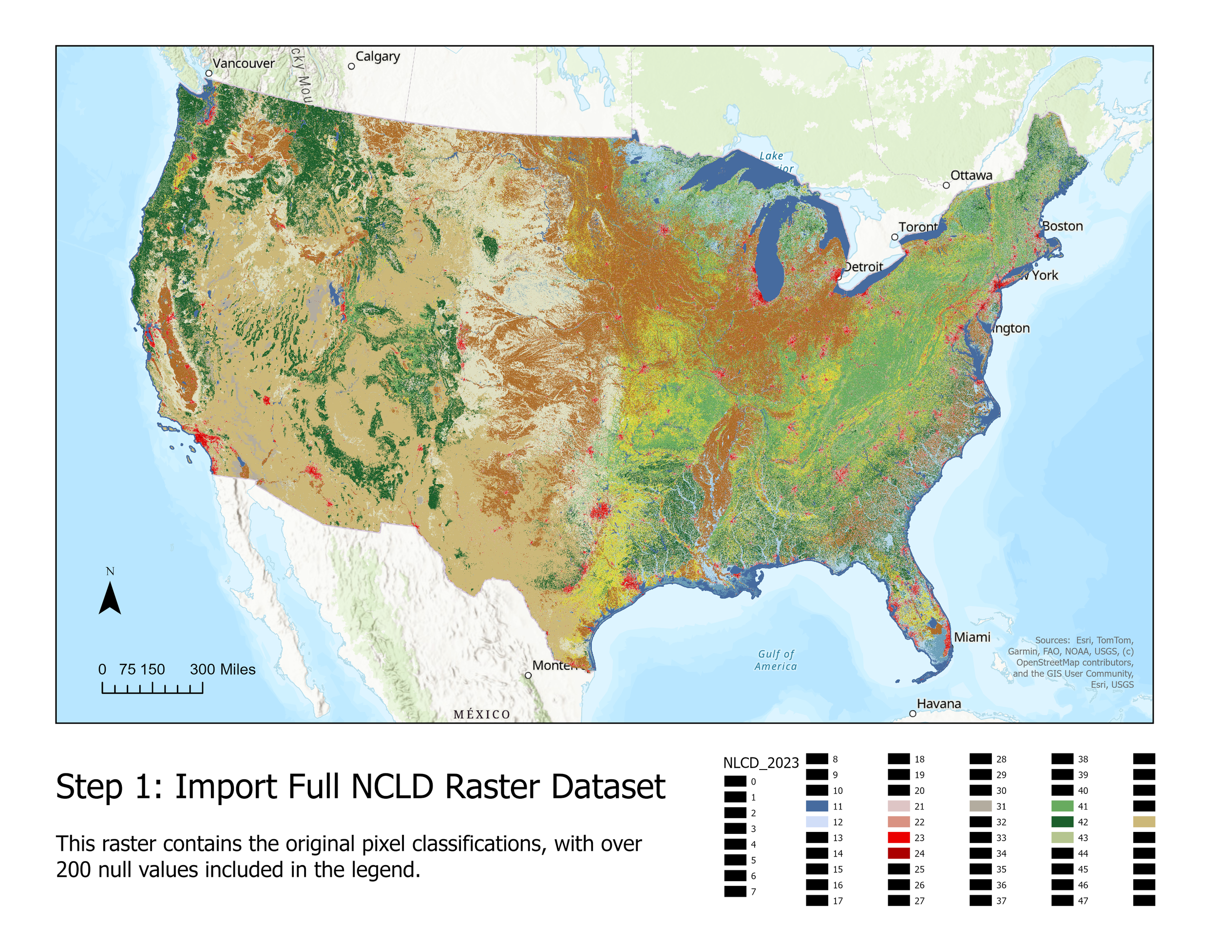
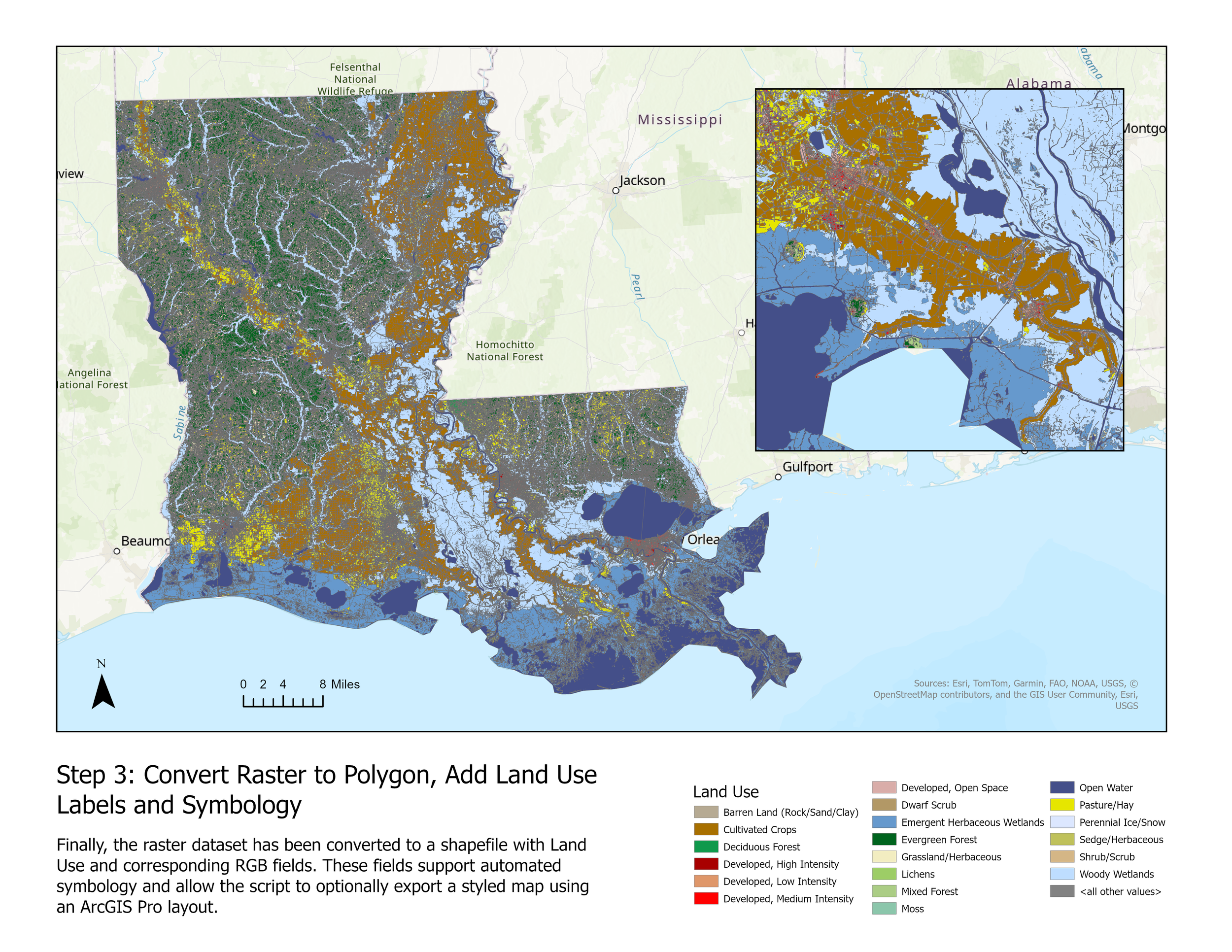
For this project, I developed a Python-based tool using Arcpy to automate the extraction, processing, & classification of land use data using the National Land Cover Database (NLCD). I used a shapefile boundary of Louisiana from the American Community Survey (ACS) for this example, in addition to the 30-meter resolution NCLD from the United States Geological Survey (USGS) and the Multi-Resolution Land Characteristics Consortium (MRLC). I implemented spatial analysis techniques including raster clipping, reprojection, raster to polygon conversion, & handling of null values. I used the Anderson Classification System & added customized RGB color codes for visualization.
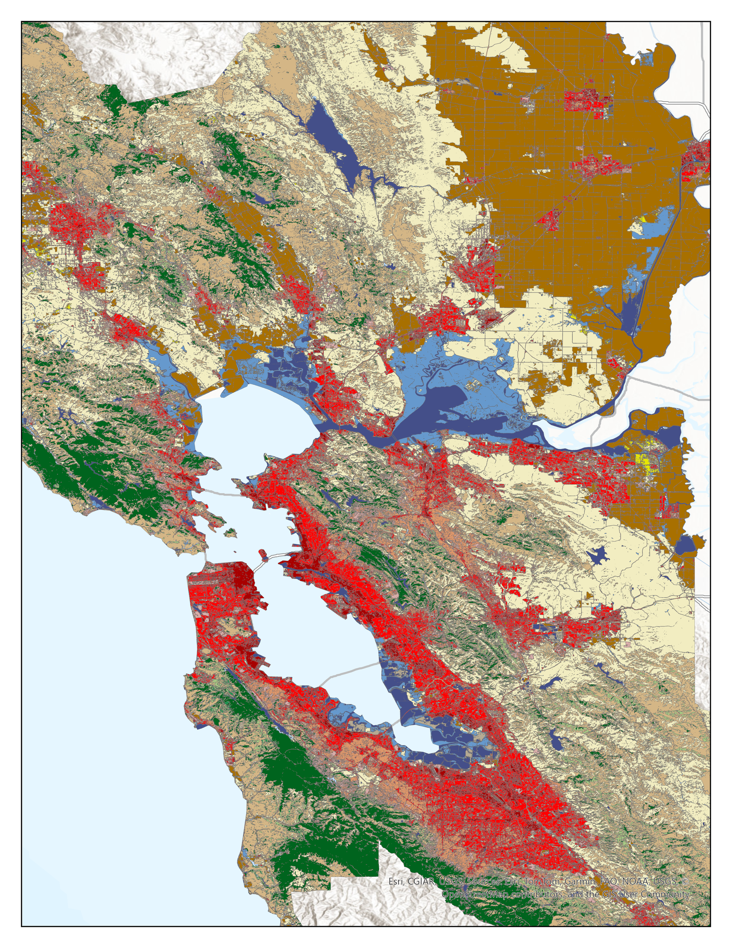
The included script automates a land use classification workflow using a user-provided shapefile boundary and NLCD land cover raster. It is designed to run in the ArcGIS Pro Python environment (arcgispro-py3) and offers optional map symbology and PNG export for visual outputs. The 2023 National Land Cover Database download link is included and a shapefile boundary of the San Francisco Bay Area are provided, but any NLCD year or alternative shapefile can be used.
Features
Reprojects shapefile to match raster projection
Clips land cover raster to the input shapefile
Converts raster to polygon
Assigns land use class names and RGB codes
Optionally applies symbology using a
.lyrxfileOptionally exports a PNG map (pictured above)

Full Script
import arcpy as ap
import os
import arcpy.mp

ap.env.workspace = input("Add your working directory and press enter: ")
print("Workspace set to:", ap.env.workspace)
ap.env.overwriteOutput = True
from arcpy.sa import*

#Creating the input and output files
input_shape = input("Enter the name of your shapefile [.shp], and press enter: ")
default_tif = "Annual_NLCD_LndCov_2023_CU_C1V0_2.tif"
print("The default raster is the 2023 NCLD land cover classification at 30-meter resolution (Annual_NLCD_LndCov_2023_CU_C1V0_2.tif)")
input_NLCD = input(f"If you're using the NLCD from a different year, enter the name here [.tif] (press Enter to use default: {default_tif}): ")
if input_NLCD.strip() == "":
    input_NLCD = default_tif

clipped_raster = "clipped_raster.tif"
input_raster = ap.Raster(input_NLCD)

symbology = os.path.join(ap.env.workspace, "LandUse_Symbology.lyrx")

#Checking projection
shape_desc = ap.Describe(input_shape)
shape_sr = shape_desc.spatialReference

#Updating missing projections to WSG 1984
if not shape_sr.name or shape_sr.name.lower() == "unknown":
    print("No spatial reference found in shapefile. Defining as WGS 1984.")
    sr = ap.SpatialReference(4326)
    ap.management.DefineProjection(input_shape, sr)
    shape_sr = ap.Describe(input_shape).spatialReference

# #Making sure projections match
raster_sr = ap.Describe(input_NLCD).spatialReference
if shape_sr.name != raster_sr.name:
    print("Reprojecting shapefile to match raster.")
    reprojected_shape = "input_shape_reprojected.shp"
    ap.management.Project(input_shape, reprojected_shape, raster_sr)
    input_shape = reprojected_shape
    shape_sr = ap.Describe(input_shape).spatialReference

print("Final shapefile projection:", shape_sr.name)
print("Final raster projection:", raster_sr.name)

#Clipping land cover data to the user's state shapefile
ap.management.Clip(input_raster, "", clipped_raster, input_shape, "NoData", "ClippingGeometry", "MAINTAIN_EXTENT")
clipped_raster_obj = ap.Raster(clipped_raster)

#Removing null values
raster_nodata = SetNull(clipped_raster_obj == 0, clipped_raster_obj)
raster_nodata.save("clean_raster.tif")
clean_raster = "clean_raster.tif"

#Converting to polygon data
landuse_polygon = "land_use.shp"
full_landuse_path = os.path.join(ap.env.workspace, landuse_polygon)
ap.RasterToPolygon_conversion(clean_raster, landuse_polygon, "SIMPLIFY", "VALUE")

fields = ap.ListFields(landuse_polygon)

# Print the name of each field
print("Fields in land use polygon after conversion:")
for field in fields:
    print("-", field.name)

# Adding a field for the land use titles
ap.AddField_management(landuse_polygon, "LandUse", "TEXT", field_length=50)

#Checking new fields
fields = ap.ListFields(landuse_polygon)
print("Updated fields after adding 'LandUse':")
for field in fields:
    print("-", field.name)

#Adding land use titles
land_use_names = {
    11: "Open Water",                  12: "Perennial Ice/Snow",
    21: "Developed, Open Space",       22: "Developed, Low Intensity",
    23: "Developed, Medium Intensity", 24: "Developed, High Intensity",
    31: "Barren Land (Rock/Sand/Clay)", 41: "Deciduous Forest",
    42: "Evergreen Forest",            43: "Mixed Forest",
    51: "Dwarf Scrub",                 52: "Shrub/Scrub",
    71: "Grassland/Herbaceous",        72: "Sedge/Herbaceous",
    73: "Lichens",                     74: "Moss",
    81: "Pasture/Hay",                 82: "Cultivated Crops",
    90: "Woody Wetlands",              95: "Emergent Herbaceous Wetlands"
}

with ap.da.UpdateCursor(landuse_polygon, ["GRIDCODE", "LandUse"]) as cursor:
    for row in cursor:
        row[1] = land_use_names.get(row[0], "Unknown")
        cursor.updateRow(row)

print("Land use name fields have been added.")

#Creating a dictionary of RGB codes corresponding to each land use class
land_use_colors = {
    "Open Water": [68, 79, 137],           "Perennial Ice/Snow": [220, 231, 255],
    "Developed, Open Space": [216, 172, 168],  "Developed, Low Intensity": [222, 150, 106],
    "Developed, Medium Intensity": [255, 0, 0], "Developed, High Intensity": [168, 0, 0],
    "Barren Land (Rock/Sand/Clay)": [182, 170, 147], "Deciduous Forest": [15, 153, 76],
    "Evergreen Forest": [0, 100, 29],       "Mixed Forest": [171, 205, 132],
    "Dwarf Scrub": [177, 152, 102],         "Shrub/Scrub": [212, 182, 134],
    "Grassland/Herbaceous": [242, 237, 193], "Sedge/Herbaceous": [191, 193, 91],
    "Lichens": [156, 205, 102],             "Moss": [138, 198, 171],
    "Pasture/Hay": [230, 230, 0],           "Cultivated Crops": [168, 112, 0],
    "Woody Wetlands": [190, 221, 255],      "Emergent Herbaceous Wetlands": [102, 153, 205]
}


#Adding the RGB codes to a new field
ap.AddField_management(landuse_polygon, "RGB_Code", "TEXT")
fields = ap.ListFields(landuse_polygon)
print("Updated fields after adding 'RGB_Code':")
for field in fields:
    print("-", field.name)

count = ap.management.GetCount(landuse_polygon)
print("Feature count in land_use.shp:", count)

try:
    with ap.da.UpdateCursor(landuse_polygon, ["LandUse", "RGB_Code"]) as cursor:
        for row in cursor:
            land_use = row[0]
            if land_use in land_use_colors:
                color = land_use_colors[land_use]
                row[1] = f"{color[0]},{color[1]},{color[2]}"
            cursor.updateRow(row)
    print("RGB values have been assigned to the 'RGB_Code' field.")
except Exception as e:
    print("error durig RGB update:", e)


# Asking user if they're running the script inside an ArcGIS project
inside_arc = input("Are you running this script inside ArcGIS Pro with the map open? (yes/no): ").strip().lower()

if inside_arc == "yes":
    print("Attempting to apply symbology in ArcGIS Pro ...")
    try:
        ap.management.ApplySymbologyFromLayer(full_landuse_path, symbology)
        print("Symbology applied :)")
    except Exception as e:
        print("Failed to apply symbology:", e)
else:
    print("Skipping symbology. Please apply LandUse_Symbology.lyrx to the landuse.shp layer manually.")

# Option to export PNG (The extent will only work for the San Fransisco area)
export_map = input("Would you like to generate a PNG of your map with symbology applied? (yes/no): ").strip().lower()

if export_map == "yes":
    print("Preparing export...")

    aprx_path = os.path.join(ap.env.workspace, "MapTemplate.aprx")
    output_png = os.path.join(ap.env.workspace, "land_use_map.png")

    try:
        # Step 2: Load the project and map
        aprx = ap.mp.ArcGISProject(aprx_path)
        map_obj = aprx.listMaps()[0]

        # Step 3: Add the symbologized shapefile to the map
        landuse_layer = map_obj.addDataFromPath(full_landuse_path)
        ap.management.ApplySymbologyFromLayer(landuse_layer, symbology)

        # Step 4: Export
        layout = aprx.listLayouts()[0] if aprx.listLayouts() else None
        if layout:
            layout.exportToPNG(output_png, resolution=300)
            print(f"Map exported to: {output_png}")
        else:
            #map_obj.defaultCamera.setExtent(map_obj.getLayerExtent(landuse_layer))
            #map_obj.exportToPNG(output_png, resolution=300)
            print(f"No Layout found.")
    except Exception as e:
        print("Failed to export map:", e)

print("All done!")